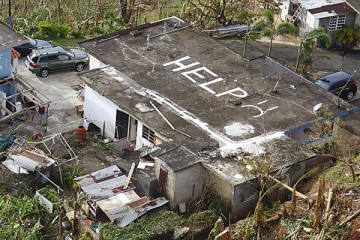
Johns Hopkins students, staff, and alums digitally mapped buildings, roads, and other critical infrastructure on Puerto Rico on Thursday as part of a global effort to help relief groups deliver supplies in the wake of Hurricane Maria.
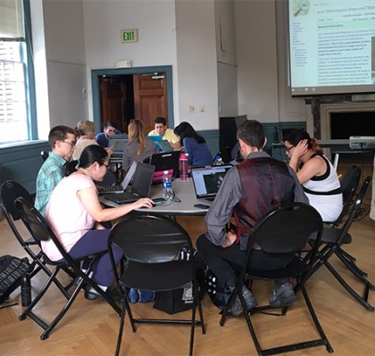
Image caption: Map-a-thon participants digitally mapped buildings, roads, and other infrastructure on Puerto Rico using OpenStreetMap.
Image credit: Sandra Files
Using OpenStreetMap—a Wikipedia-like tool for mapping—participants in the map-a-thon used satellite images to fill in missing details on existing maps, particularly in remote areas of the island.
Dale Kunce, who heads the Humanitarian OpenStreetMap Team, or HOT, a nonprofit that uses the site to map countries after a disaster, told The Baltimore Sun that as many as 6,000 people have joined the effort to map countries struck by Hurricanes Irma and Maria.
More from The Baltimore Sun:
Read more from The Baltimore SunWhile anyone can go on the website to help, colleges like Hopkins have been particularly active in hosting group events to explain the process and even help get those unskilled in mapping to contribute to the effort.
"I think many of us want to contribute in any way that is helpful," said Mara Rojeski Blake, data services manager at Hopkins' Sheridan Libraries and Museums, who organized the event at Levering Hall on the Homewood campus.
She led a couple of dozen students, staff and alumni, all gazing intently at their laptops, through a quick tutorial. They created OpenStreetMap accounts, then went onto a list of tasks that HOT had compiled, each ranked by urgency. That led to maps of various parts of Puerto Rico that were further divided into grids. Participants clicked on grids that had yet to be mapped, which led them to satellite images that were taken before the hurricane.
The listed tasks called for mappers to mostly focus on buildings. Some were fairly easy to trace, urban neighborhoods with streets of what obviously were single-family homes. Other grids were more rural, with what looked to be a building or two, surrounded by fields or other undeveloped land. Still others showed larger structures that may have been apartment or office buildings. Some images were harder to scope out—trees blocked part of a structure, sometimes a massing could have been either a building or a shadow.
Posted in Science+Technology
Tagged disaster response, hurricanes