

The ocean has thermometers.
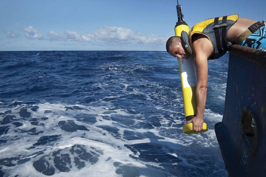
At this moment, underneath the waves in every ocean on the planet silently swim, or rather drift with the currents, a fleet of 5-foot-long probes the shape of giant EpiPens. Called Argo, this international array of nearly 4,000 self-submerging robots can dive to depths of 2,000 meters—or more—to measure ocean temperature and salinity before briefly surfacing to transmit their observations, via a skinny black antenna, to satellites.
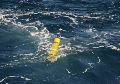
Image credit: Argo program
Then they dive again. These mini observatories spend their next 10 days patrolling underwater before returning to the surface—and the whole process repeats.
The first-ever global ocean-observing network, Argo enables scientists to understand the ocean's role in the Earth's climate, as well as to track the evolution of our oceans and seas, which have shown continuous warming. We have long known that greenhouse gases released via the burning of fossil fuels trap heat in our atmosphere, and the vast bulk of this excess heat is being absorbed by the ocean and moved around the world through air and currents.
Since the program's inception two decades ago, the near-real-time data collected has helped scientists worldwide predict such things as rainfall patterns, intensity of hurricanes, and sea level rise. Some of the fleet's newer-generation floats can dive even deeper than 2,000 meters, more than a mile down, and measure properties that describe the ocean's changing biology and chemistry.
Before Argo, we knew more about the surface of the moon than about the depths of the ocean, and certainly more about the Earth's atmosphere, says Breck Owens, A&S '75 (PhD), current Argo director and a senior scientist of physical oceanography at Woods Hole Oceanographic Institution in Massachusetts.
Owens was instrumental in establishing this revolutionary program that paired great scientific need with technological innovation. In some ways, he says, it all began at a conference lunch break.
In the early 1990s, Owens and Russ Davis, a physical oceanographer at the Scripps Institution of Oceanography in San Diego, were developing automated ocean glider and float technology outfitted with sensors to take ocean measurements. The two had worked on the World Ocean Circulation Experiment, an eight-year (1990–98) precursor to Argo that helped establish the role of the oceans in the Earth's climate system. But WOCE's payoff was a long game. Research vessels traveled miles at sea and stopped every few hours to lower instruments to the seafloor to sample water temperature, salinity, and pressure. These transect missions took months to complete, the comprehensive data years to compile. During WOCE's field phase, Davis and Doug Webb, an engineer at Woods Hole, invented a float that used the principle of neutral buoyancy to drift with currents and autonomously rise and descend. For its sole propulsion system, an internal battery-driven pump transferred oil between a reservoir inside the float to an external bladder that raises the device by displacing weight, making it lighter than the surrounding water. If equipped with sensors, Davis and Owens realized, the floats could measure the temperature and salinity of the water through which they rose, a process much faster and cheaper than lowering instruments from boats.
As proof of concept, the two proposed an experiment to launch 200 of these floats to profile, or map out, temperature and salinity in the North Atlantic, roughly from Newfoundland to the southern tip of Greenland. They deployed the floats over several nausea-inducing boat trips in rough seas, dropping them overboard and then waiting for the data to come back. "Most importantly, we got what we were looking for," Owens says. "We proved that the technology was in place to do Argo on a global scale."
In early 1997, Owens and Dean Roemmich, a physical oceanographer at Scripps, had lunch at a conference held at the U.S. National Center for Atmospheric Research in Boulder, Colorado. Seated at their table was NASA physical oceanography program scientist Eric Lindstrom, who talked about the satellite that monitored the world's oceans, and how modern altimetry—measuring the satellite-to-surface round-trip time of a radar pulse—has revolutionized the study of climate variability and sea surface height. "And we said: 'Hey, Eric, it's cool that you have these satellites that measure the surface temperature and sea level from space, but wouldn't you want to know what's going on beneath the surface?" Owens recalls. "Following that meeting, Dean and I wrote a white paper that was the basically the concept of Argo."
The initial plan was for a 3,000 float array deployed over the next decade, organized by the National Oceanic and Atmospheric Administration. The name Argo was chosen because the floats work in partnership with the Jason Earth-observing satellites that measure the shape of the ocean surface. In Greek mythology, Jason sailed on his ship, the Argo, in search of the Golden Fleece.
But to work, the floats needed to be dispersed across the globe, which required the cooperation of the worldwide scientific community and government agencies. Enter Stan Wilson, A&S '72 (PhD).
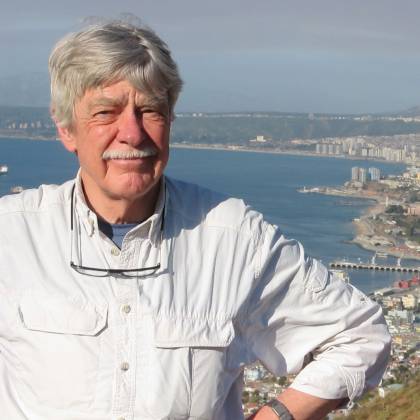
Image caption: Stan Wilson
After graduating from Johns Hopkins, Wilson worked at the Office of Naval Research where he led its program in physical oceanography to, among other things, help improve the Navy's ability to track submarines through sonar. Since ocean temperature affects sound propagation, the Navy conducted several surveys where they lined up ships to drop extendable thermal probes to create a heat map of a relatively small section of the ocean. Wilson was later recruited by NASA in 1979 to lead the development of its Oceanography from Space Program, which eventually resulted in the successful launch of the TOPEX/Poseidon, and SeaWiFS missions. University-based oceanographers partnered with NASA remote sensing engineers to use these satellites to help determine such things as sea ice cover, surface temperature, sea levels, and ocean color—in the absence of chlorophyll, water appears blue.
"Our first global estimate of sea level rise came out of the NASA program," he says. "But there was a problem; satellites could only see the surface patterns of the ocean, meaning you don't know vertical extent. The electromagnetic waves can't penetrate the ocean surface and propagate worth a damn. Think of it like a fog bank shrouding a forest."
When Wilson, then a deputy chief scientist at the NOAA, learned what Owens and Roemmich were doing with Argo, he saw an opportunity to realize his long-held dream of seeing the weather patterns of the world's oceans.
"I instantly appreciated it," Wilson says. "I'm not a theoretician, I'm a practical person. I was like, if we can get enough floats out there, you get the third dimension needed to discern weather patterns in the ocean, just like a barometer and thermometer for the atmosphere."
Yes, the ocean has weather patterns. Whereas the atmosphere has jet streams, the ocean has the Gulf Stream. It also has low pressure systems, temperature variations, and eddies—huge masses of spinning water that are the oceanic equivalent of a hurricane but less destructive as they can draw nutrients up from the deep. Like weather on land, oceanic weather conditions can impact where marine life wants to and is able to live. Then there are ocean phenomena like El Niño, the unusual warming of surface waters in the eastern tropical Pacific Ocean. El Niño can affect our weather significantly, turning regions wetter or drier.
But enormous hurdles to Argo realization existed, including the cost and feasibility of global deployment. Under Wilson's leadership as U.S. representative to the Intergovernmental Oceanographic Commission of UNESCO, NOAA played a central role by methodically promoting Argo to scientific and government agencies in Europe, North America, Asia, and Australia to help fund and grow the program.
"Stan's role in Argo cannot be emphasized enough," Owens says. "He was critical in helping [to set up] the structure within the U.N. commission to make it happen. Clearly we needed scientific leadership, but Stan was the salesman to make it happen."
The international Argo Science Team held its initial meeting in March 1999 to begin planning its implementation. It was decided early on that all data would be publicly available without restriction, a policy that Owens says has aided Argo's international growth.
"We wanted this data to not just belong to the people who made the measurements but to the world, as fast as we can make it available," Owens says. "That actually changed how modern oceanography works. Every climate center, weather center, and member of the research community has access to our data."
The first floats were deployed by Argo Australia in the Indian Ocean in late 1999. Over the next two years, hundreds more were launched in the tropics, the North Atlantic, and the Pacific Ocean. Since 2006, three years ahead of schedule, Argo has provided global coverage of the upper 2,000 meters of all oceans.
All this with no central funding. Each of the 30 partner countries obtains its own national funding to buy floats (between $20,000 and $150,000), prepare and launch them, and process and distribute the data. As part of the Global Ocean Observing System and the Global Climate Observing System, Argo is centrally managed by a team of scientists and data experts who vigorously scrutinize all measurements before sending to the program's two Global Data Assembly Centers in Brest, France, and Monterey, California. The total annual cost of Argo is estimated at $40 million.
At present, Argo collects roughly 12,000 data snapshots each month, 400 a day. The measurements allow us to monitor from year to year how the distribution of heat changes depending on depth and location. To date, over 4,400 scientific publications have referred to or used Argo data.
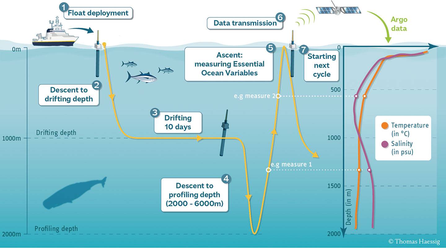
Image credit: Thomas Haessig
Since its inception, innovative new designs have allowed floats to profile deeper—up to 6,000 feet with the Deep Argo project—and to work in ice-covered regions using floats equipped with ice-avoidance algorithms. Some new floats are equipped with biogeochemical sensors (BCG Argo) to gather data on levels of oxygen, nitrates, pH, and chlorophyll. Such information is critical to understanding how human activity contributes to trends such as carbon dioxide increase, oxygen loss, ocean acidification, and algae blooms. The future of Argo, Owens says, is to create a fully global, top-to-bottom, dynamically complete view of the ocean.
"We're trying to look at not just the physical response of the ocean to climate change but the biological processes as well, such as how the physical properties get moved around," Owens says.
What becomes of the floats? They eventually stop and sink. Some are caught in fishing nets, and the occasional one washes up on the beach. Each comes with a return address. The first-generation floats lasted at most two years before the batteries died. The newer ones last up to 10 years. Owens says collecting them at sea would be ideal, but it's currently cost prohibitive and impractical, so one day a float simply dies at a depth where its metal casing will dissolve over decades. "We're not perfect or cavalier about dumping things into the ocean," Owens says, "there is some plastic and lithium, but in the scheme of things it's a tiny amount compared to runoff or what falls off container ships annually."
Jim Bellingham, a pioneer in the development of autonomous marine robots and former director of the Consortium for Marine Robotics at Woods Hole Oceanographic Institution, describes Argo as a scientific triumph. Bellingham, who now directs the Johns Hopkins Institute for Assured Autonomy, first met Owens while at Woods Hole and realized the profound impact of being able to take the holistic heat record of the ocean.
"In our knowledge of the Earth's climate system, and wondering what our future world will be like, one of the principal impediments to predicting that with certainty was our poor observation of the ocean. It's the biggest part of the planet and the largest heat reservoir, but it was horribly underinstrumented compared to the atmosphere," Bellingham says. "Argo was this ridiculously inexpensive way of monitoring the temp and salinity with these floating thermometers to give us that physical snapshot we needed. They say necessity is the mother of invention, and Argo is one great example of this."
Posted in Science+Technology
Tagged robotics, satellites, oceanography, noaa, the ocean issue, argo